This post may contain Amazon Affiliate links for which I may receive compensation.
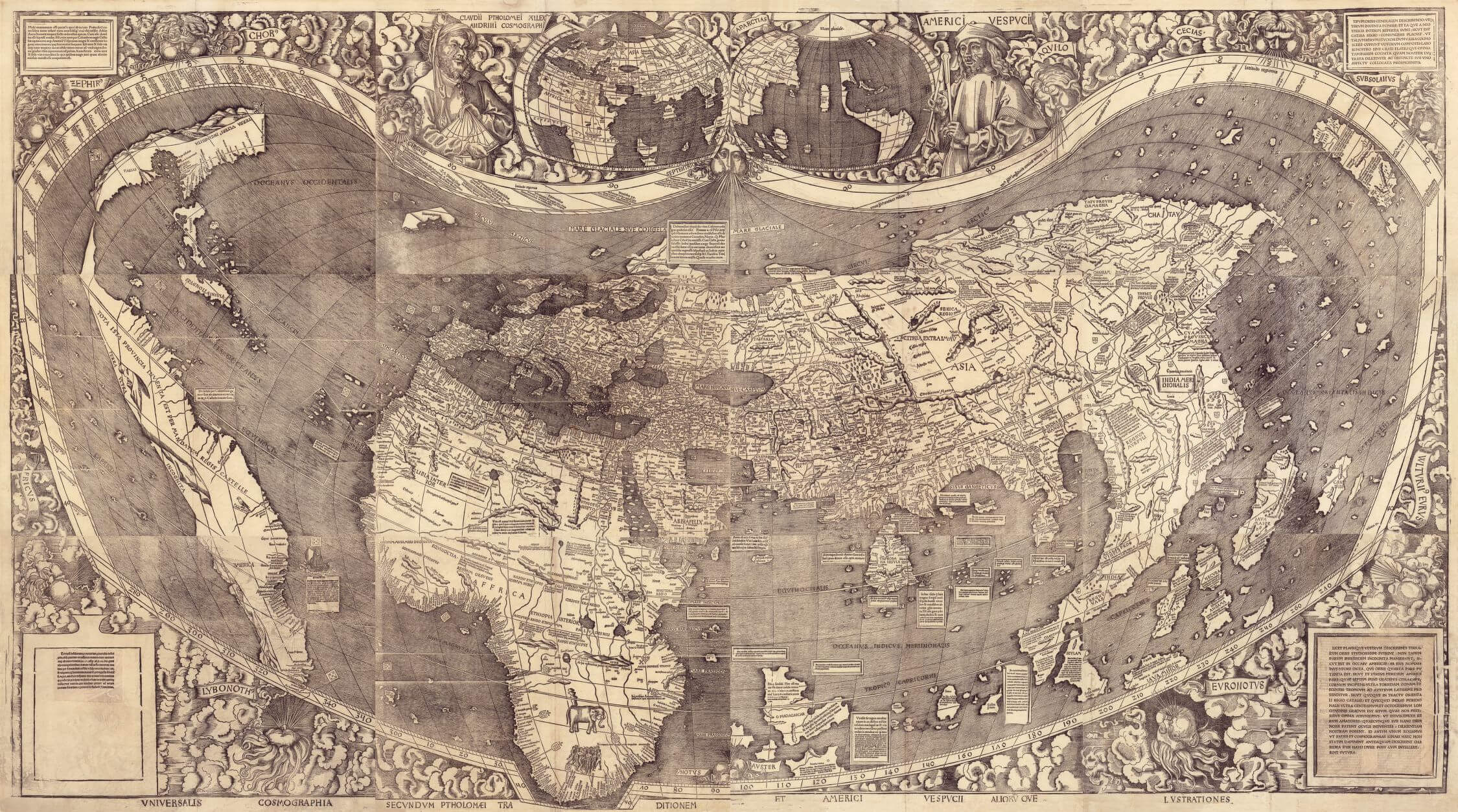
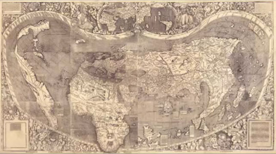
“For his 1516 “Carta Marina” world map, the German cartographer Martin Waldseemüller completely changed his approach to map making, compared to his famous 1507 world map.”
In 2012, in a fascinating presentation, scholar Chet Van Duzer took us back to the 16th century and step by step – very eloquently – highlighted the techniques and the references used by the cartographer when creating these two maps. The speaker included numerous visual images of the maps’ details in his presentation and often referred to explorers’ narratives of that period, making his talk captivating.
The 50-minute presentation can be watched on Youtube (Legends on Martin Waldseemüller’s Carta Marina of 1516) and the two extraordinary maps can be seen at the “Exploring the Early Americas“ exhibition, at the Library of Congress, Washington DC.
Martin Waldseemüller’s 1507 map, titled “A Map of the Whole World According to the Tradition of Ptolemy and the Explorations of Amerigo Vespucci and Others”, is based on the work of Ptolemy (Alexandria, 2nd century A.D.), Chet Van Duzer explained, whereas his 1516 map used nautical charts and the writings of recent explorers, to produce a beautiful rendering of the world, with numerous graphical details.
1507: A Map of the World According to Ptolemy and Vespucci
Credit: Library of Congress – Jay I. Kislak Collection
The 1507 Waldseemüller’s map is printed on 12 sheets, 4 x 7.5 feet, Van Duzer continues and is based on the cartography techniques of Ptolemic projections and longitudes and latitudes.
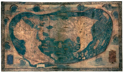
Interestingly, it takes a lot of its features from the 1490 map of cartographer Henricus Martellus (Yale University, Beinecke Library), with some personal additions, particularly when it comes to the New World.
We can easily point out the similarities between the two maps:
- Projection techniques
- Overall shape
- Representation of longitude and latitude scales
- Graphical representations of “wind heads”
- Shape of Asia: the Indonesia-Malaysia region and Japan
- Legends
- Position of text blocks.
But we can also easily see Waldseemüller’s additions: the map represents 360 degrees of longitude (versus around 230 degrees for Martellus’s map), extending to the West, and to the South; it shows the entire African continent, as well as the Pacific Ocean before Balboa discovered it in 1513.
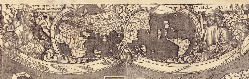
The map credits the discovery of the new world to Vespucci and is famous for being the first map to call the New World “America”. It is believed, however, that the body of water shown to the West of “America” was the fruit of deduction, rather than knowledge. Indeed, Marco Polo had said in his writings that Japan was an island 1,500 miles east to the eastern part of the Asian continent, and Vespucci claimed that “America” was not Asia. That would imply that there had to be a body of water between the island of Japan and the American continent!
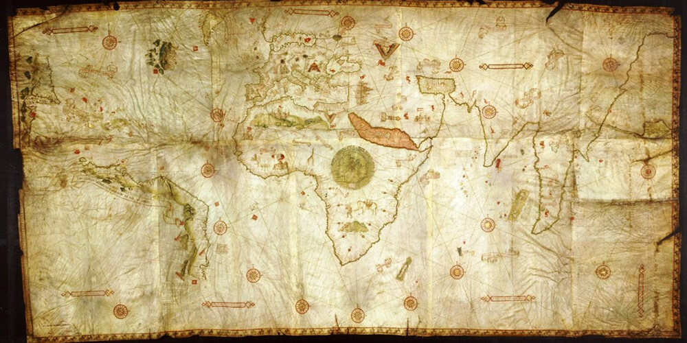
1516: A “Carta Marina” Based on Nautical Charts and New Explorations
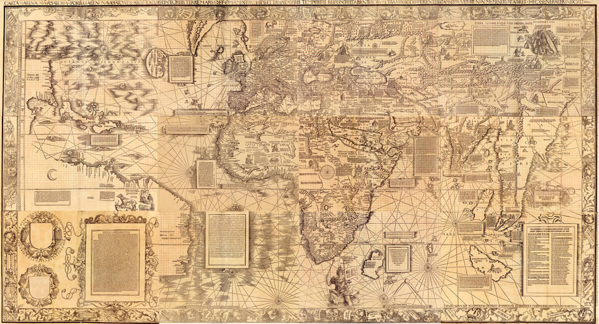
Only nine years later, Waldseemüller draws another world map, of similar size, but the differences are striking. For his “Carta Marina” – as it is called – Waldseemüller has abandoned Ptolemy’s techniques and, this time, designed a world map based on nautical charts, emphasizing coastal lines, and showing a system of rhumb lines (construction of such system explained here) which were used in navigation as a reference, for reading and marking directions (courses) between places. More original, more detailed, and containing more graphical elements, the map is an entirely new image of the world, based on new sources, Chet Van Duzer explained. Its title speaks for itself: it is “a nautical chart that comprehensively shows the Portuguese voyages and the shape of the whole known world… its regions, and its limits as they are determined in our times, and how they differ from the tradition of the ancients, and also areas not mentioned by the ancients.”
It is thought to be the first printed nautical chart of the entire world.
As a model, Waldseemüller seemed to have used the 1503 map from Nicolo de Caverio, from Genoa, said Van Duzer (see the comment at end of the article on other maps which could have inspired Waldseemüller).
Again, similarities are easily seen:
- Shape of Africa, Southern Asia
- Location of Greenland and Labrador
- Shape of South America’s coastal line
- Location of the rhumb lines
But remarkably, the “Carta Marina” does not show the Pacific Ocean anymore, nor does it mention America. It mentions Columbus as the discoverer of the American continent, and as Columbus believed he had reached Asia, such a belief influences the cartographer. You can even read Cuba mentioned as “part of Asia”.
Interestingly, the map is also now restricted to the “known” areas of the world. It covers 120 degrees in longitude less than the 1507 map and shows less of the Northern areas, but it allowed the cartographer to include numerous and gorgeous graphical details.
“Carta Marina” – Truly a Renaissance Visual Encyclopedia
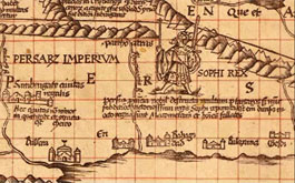
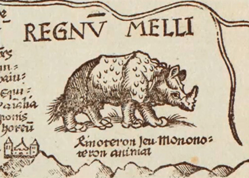
Indeed the map is rich with descriptive texts and iconography, making it very informative from a geographic, political, and even practical point of view. It includes – for example – illustrations of several royal rulers and even a list of prices for spices at the Calicut spice market (text box lower right corner)!
Van Duzer has studied extensively travelers’ books of the time, to find the sources that inspired Waldseemüller, including 3 books that he mentioned in his talk – “Paesi Novamente ritrovati” (1507), Springer’s travel narrative (1509), and Varthema’s travel narrative (1515), which is also at the Library of Congress.
And it is fascinating to see the similarities between the “Carta Marina” and those books’ illustrations. I hope he won’t mind me borrowing some of his images to share a few of his examples here.
-
- Sophi, King of Persia inspired by an illustration from Varthema’s travel narrative (1515),
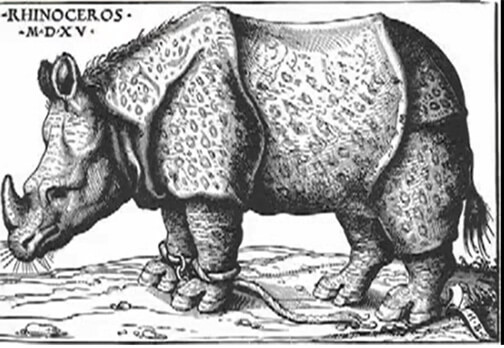
- The rhinoceros which illustration was found in Hans Burgkmair’s book (1515),
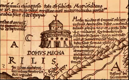
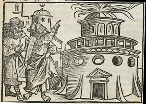
- A delightful illustration of the Mecca – also inspired by Varthema,
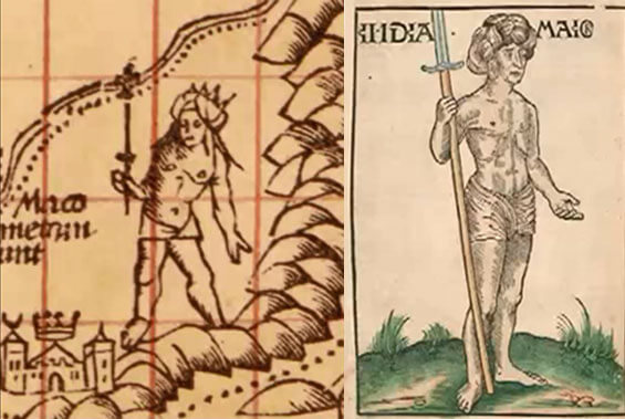
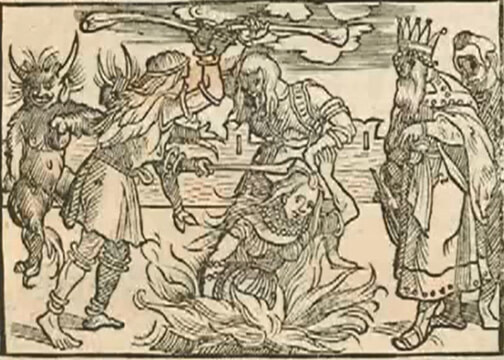
- A King in India resembling an illustration from Springer’s travels (1509),
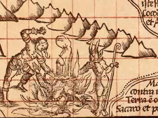
- The tradition of the suttee (the Hindu practice of the widow burning to death on the funeral pyre of her husband) in India – also from Varthema,
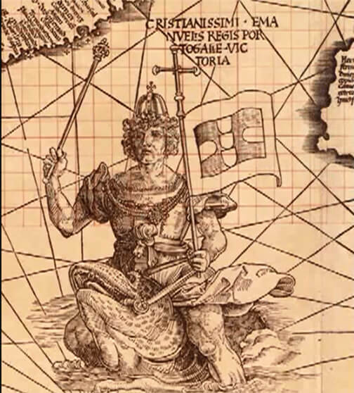
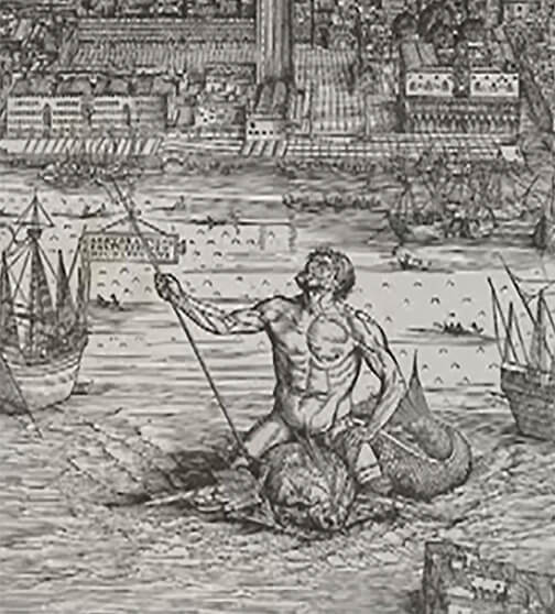
- And finally the King Manuel of Portugal, shown as dominating the sea, symbol of his hegemony over the sea route around Africa and to India (after Vasco da Gama’s voyage around Africa opened Portuguese trade with the East). The image seems to be inspired by an illustration of Neptune riding a sea monster on printmaker Jacopo de Barbari’s view of Venice, c. 1500.
I am sure the map contains many more of those fascinating illustrations. Clearly, the map needs to be seen “up close and personal” to appreciate all of its beauty. Sounds like a worthwhile visit to the “Exploring the Early Americas” exhibition, at the Library of Congress, Washington DC.!
Note on the speaker: Chet Van Duzer has devoted his life to maps since 1997. His books include:
- “Seeing the World Anew: The Radical Vision of Martin Waldseemüller’s 1507 & 1516 World Maps”, Levenger Press, 2012.
- Sea Monsters on Medieval and Renaissance Maps
- Floating Islands: A Global Bibliography
- Johann Schoner’s Globe of 1515: Transcription and Study: Transactions, APS (Vol. 100, Part 5)
Other maps which could have inspired Martin Waldseemüller’s Carta Marina of 1516:
On the MapHist forum, Joaquim Alves Gaspar, CIUHCT, University of Lisboni, commented that:
- The Carta Marina is indeed very similar to the Caverio planisphere (1505) and was most probably based on it. But the Caverio itself is copied from the Cantino planisphere (1502) and other unknown Portuguese sources of the time;
- In the Cantino, the separation between Asia and America seems clear: there is a legend reading “Oceanus occideroriêntalis” which probably means “an ocean eastward of China and westward of America”.