Are you surprised by the question? Well, actually Lake Champlain was part of New France for more than 150 years, from 1609 to 1759. But that part of its history tends to be forgotten. And it makes sense why. “Losers” are often forgotten in history, and definitely the presence of French people in this region ended with a defeat of the French and the conclusion of a chapter in history. In 1759, New France was no more. France had turned the page.
In 2009, for the 400th anniversary of Lake Champlain and its discovery by Samuel de Champlain in 1609, we thought it would be a good time to make a voyage into the past.
Such trip took us all around Lake Champlain, on both the Vermont and New York sides of the lake and all the way North into the Richelieu River, in Quebec.
The story starts in Isle La Motte, where Samuel de Champlain is said to have put a foot in early July 1609. (At the end of July, he would fight the Iroquois in the area of Ticonderoga). On Isle La Motte, you can see one of the statues of Samuel de Champlain, with his Indian traveler companion.
You will also learn that Isle La Motte is actually the first European settlement in Vermont (we did not know!)… a French settlement naturally, as Captain Pierre La Motte and its Carignan-Salieres regiment built Fort Sainte-Anne there in 1666. That settlement was not going to last long, though.
Today, there is no trace of the wooden fort of Fort Sainte-Anne but the site is a nice place for a picnic… with grass, trees and a nice view of the lake… and definitely a superb place for a wedding, with its outdoors church (St-Anne’s Shrine)… what a setting!
As time passed, the French moved down the lake and built two forts on the New York side, directly south of Montreal, to protect themselves (and their fur trade in Montreal) against first the Indians and later against the British from the South. Rivière Richelieu and Lake Champlain were a key communication pathway, at a time when traveling by land remained very challenging.
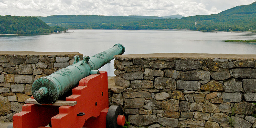
The French built the first of these forts in 1733-1734 and they called it Fort Saint-Frederic. At Crown Point, you can still see the ruins of the French stone fort. You will also see the ruins of the larger British fort of Crown Point, built later, with the British flag still standing high in the sky.
Once again, a very nice setting with a great dominating view of the lake. If you cross to Chimney Point by ferry, you’ll also learn about the French settlements in the first half of the 18th century.
As we drive down the lake back on the New York side, you’ll come across Fort Ticonderoga, a majestic stone star-shaped fort with a rich history from the time of the French and Indian War (the mid-1700s) and the American Revolution.
Built by the French in 1755-1757, the French had named it Fort Carillon. Its star shape is highly characteristic of French military architecture of the time, and you may have seen other examples of it if you visited La Citadelle (1820) in Quebec City, Fort McHenry (1796-1803) in Baltimore, or Fort Warren (1833) on George’s Island in Boston harbor.
They are all designed according to a defense system developed by a 17th-century French military engineer named Sébastien de Vauban.
Fort Ticonderoga definitely saw a lot of military action, captured successively by the British, the Americans (Ethan Allen and his Green Mountain Boys), and again by the British.
Allow two to three hours for a visit. Among other things, Fort Ticonderoga has one of the largest collections of British engraved powder horns in the country.
Then make sure to take the ferry to admire a great view of the fort, from the hills of Mount Independence’s historic site, VT.
Our trip was not over yet, and the next day we discovered the 1750 Fort Chambly in Quebec, remarkably renovated and with a spectacular exhibit on the history of the whole region all the way from Quebec City to Albany, NY. But that will be for one of our upcoming articles!
More information:
– Fort Ticonderoga site
– Crown Point site
– Fort Chambly site
Christine
Yes ! We share many interests! from sabotier to Saratoga, Fort St Frederic, Carillon, and so much more.
Theodore Corbett’s “Clash of Cultures on the Warpath of Nations” has been a great resource about Fort St Frederic as well as on the French raid on Saratoga Plantation when in 1745 when Philip Schuyler was killed in the defense of his family’s plantation. Sometimes I try to imaging what our world would be like today if the French were the victors of the Seven Years War…..The Champlain Valley would still speak French and perhaps Saratoga too.
Yesterday I was in Cohoes (in Albany County NY) to take my first ride on the Bike trail there, stopped in a little breakfast shop and as we left the very old Salada Tea advertisement /sign on the exit door said “Merci…Revenir bientôt” !!
I need to read this book from Corbett you are talking about. I am right now reading the journal about the French raid to Saratoga in 1745. I attended the presentation about it the other day at the Saratoga National Historical Park, and then talked a lot with Christine Valosin and Chris Martin at the War College on the Seven Years War at Fort Ticonderoga. I should put you in touch. They are very actively doing research about French settlers in the Saratoga region and are looking for information on Beaujeu who had a seigneurie on Lake Champlain.
I wrote The Clash of Cultures on the Warpath of Nations. I helped Chris Martin develop a research program on the raid this past summer. Christine has helped me a bit with illustrations for my next book, The Saratoga Campaign: No Turning Point, which will be out in fall 2012.
Do you have questions?
Hello Ted,
Thanks for reaching out. Personally I am really interested to locate the exact position of French farms on the shores of Lake Champlain, so I try to read every book which may have descriptions of places…
I am also very curious to try to figure out where was the cemetery located at Fort Saint-Frédéric. It seems it remains a mystery even though a number of French people were buried there.
The 1752 journal of Phineas Stevens will give you some general locations of French houses and villages. 1749 Peter Kalm also describes where he sees houses/ villages. Remember for distances the difference in French leagues/miles as opposed to English. There were houses at Mouth of Chazy river. Read about Louise de Ramizay and her sawmill contracts for other locations of houses. Jean Chartier (John Carter) sawyer. (Possibly a sawmill at Ausable River or near Wickhmas Marsh.