This post may contain Amazon Affiliate links for which I may receive compensation.
Photo credit: Courtesy of Barry Lawrence Ruderman Antique Maps ─ RareMaps.com
The Johann Ruysch and Martin Waldeseemüller World Maps
The Interplay and Merging of Early Sixteenth Century New World Cartographies
Gregory C. McIntosh
2012 Plus Ultra Publishing Company
This is a little book published by its author Gregory C. McIntosh who has obviously spent years of his life studying these world maps.
Could you imagine that we can see corrections on copper plates or wood blocks of early 16th century maps and discover which changes were made from the time they were first printed to later printings?
That is one of the fascinating things you’ll discover in this book.
But the book is definitely more for scholars than for a general audience. It describes in extensive detail the differences in wording and shapes of landmasses between maps or even between several editions of the same map. On that topic, the last few pages include a long table detailing such information.
The reason is that the interest of the author ─ and of other cartography historians as we have seen in our series of articles “Cartography of the New World” ─ is to understand which map was drawn before another map, which mapmaker first described a certain region, or named a certain place. By analyzing every map in scrutiny and classifying maps in groups maps (the Lusitano-Germanic or King types in the present case) based on their similarities or differences, historians are able to conclude which other maps and explorers’ journals the mapmakers of the time had access to when they drew and published their world maps of 1507, 1508 or 1516.
It is possible that you may not care too much about the author’s theory that the first edition of the Ruysch world map was of a King-type but that its latter editions incorporated elements from Lusitano-Germanic type maps, but you may be interested to learn about the unusual life of Johann Ruysch, a Flemish monk born in Utrecht, who may have traveled to Newfoundland with John Cabot, lived in Germany and in Rome, where he painted the papal apartments with Raphael, and then went to Lisbon, where he was made an official by King Manuel. He then may have traveled to Africa, India, Brazil, and Newfoundland and died in 1533 in a monastery in Cologne, at the advanced age of 75.
But for me, the most FASCINATING part of this book was to learn that you can still discern on those maps the corrections which were made to the original copper plates (Ruysch map) or wood blocks (Waldseemüller maps), from one edition to another, by carefully looking at the graphic representation of coastlines or sea waves or some typographic details.
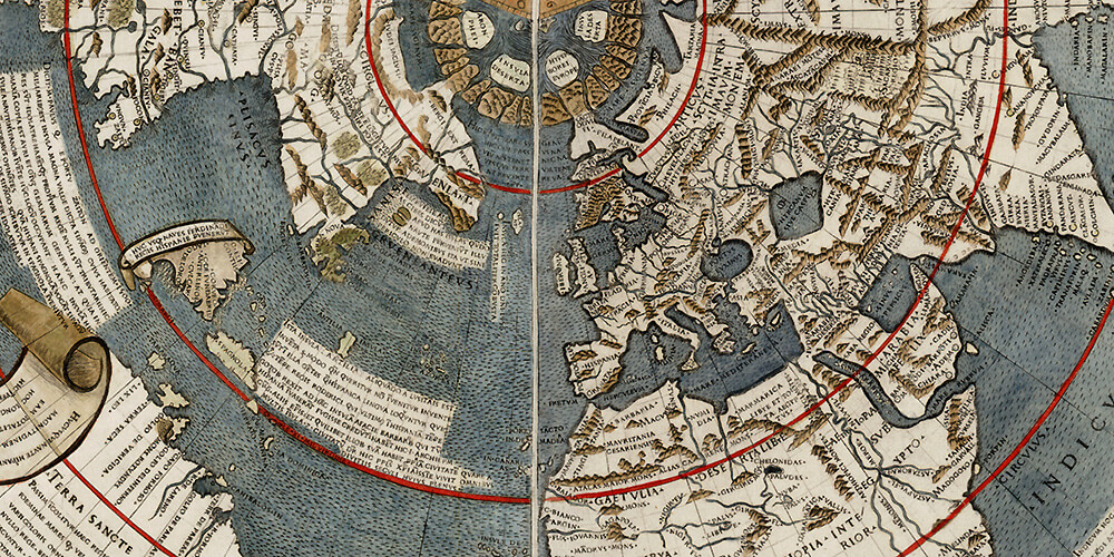
There is no doubt that his world map is of major importance to the history of cartography. Of a fan shape and polar projection, like the 1506 Contarini-Rosselli map it is modeled from, it depicts the world as two 180-degree parts ─ the Ptolemy old world and the New World. Published in 1508 it is one of the earliest printed world maps and includes the recent European discoveries in the New World, Africa, and South Asia.
If you happen to read this book The Johannes Ruysch and Martin Waldseemüller World Maps: The Interplay and Merging of Early Sixteenth Century New World Cartographies (available on Amazon), make sure to share your opinion with us here!
Footnote: You may wonder what Lusitano-Germanic or King-type maps are. I am sure they teach about those in cartography classes, but finding definitions online is not an easy thing to do.
The book offers such definitions. The characteristics of Lusitano-Germanic maps include:
- Greenland is a large triangular peninsula
- Newfoundland is a half-island unattached to any continent
- Hispaniola is called Espanola
- There is a large continental landmass to the west of Cuba
- South America has a continuous coastline from Venezuela to southern Brazil
- Some toponyms in South America are distinctive to this group of maps.
Maps in this group include the Cantino map (1502), the Caverio map (1503), the Waldseemüller maps of 1507 and 1516, and his “Tabula Terre Nove” 1513 map.
On the other hand, King-type New World map design ─ named after the King-Hamy 1502-1503 manuscript planisphere ─ is divided into three distinct regions and characterized by:
- Greenland is a narrow east-west island called “Terra Labrador”
- Newfoundland is a half-island due west of “Terra Labrador” and called “Terra Cortrealis”
- Some toponyms in the Caribbean are distinctive to this group of maps
- Cuba is smaller and thinner and called “Terra de Cuba”
- The coast of Brazil may be separate from the north coast of South America
Maps in this group include the 1504 Fano-Maggiolo map and the Kunstmann N°2 map (probably 1505).
Hope that clarifies it!
Hi, I write from Bretagne, west of France, same place as Christine it seems. sorry I didn’t read the book yet. But I DISAGREE with the credit of this map to Johannes Ruysch, who, its a fact, never produced any other cartography work. To my opinion he did not more then the drawing. He was just an assistant of the breton bishop Robert Guibé who has got his coat-of-arms on the front page of the book – fact – ( hiden in the decoration drawing) and his twice cited and thanked by Beneventanus and french editor Tosinus – fact. Robert Guibé was close to the pope, got the ‘prilege of 10 years’ from him, payed for the book and also contributed in providing informations he gathered from others bishops, diplomats, probably also from Bretagne fishermen and one of his brother who was admiral of the duchess Anne. He without any doubt designed the Bretagne part of the Tabula Francie Moderna, featuring names of towns for the first time and which only a breton man could know. On the world map you can also see that the Britania duchy is indicated, it is the only duchy. You can have a description of the PDF link below (or on request by email) this PDF is a simple ‘teaser’ for Facebook I published localy in january, showing the work I am doing. It was approved by the french BNF and Robert Guibé as been added in the credits of the book as you can check, and, I hope, will be for the world map which is a part of it soon or later. I can also provide another PDF with more detailed arguments. Correcting all american school books is now something to consider (smile). m Yvon Jaouen, Lãnderneav, Britania, Francie