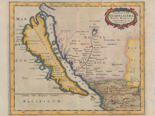
Photo: 1666 Map of California, by Pieter Goos, courtesy of the Glen McLaughlin map collection.
A great story. It all started in a London map store when Glen McLaughlin, a Californian venture capitalist, noticed a 1663 map on which California was an island. He was curious, bought it, brought it home, and hung it in his living room. It quickly became a conversation piece, and the rest is history. Mr. McLaughlin was hooked and he would buy old maps with the “island of California” for the next 40 years… nearly 800 of them, making it the largest privately-held collection known on the topic!
The reality is that in fact, for more than two centuries, California was shown on maps as an island. Even a Japanese map from 1865 still showed the error!
But let’s go back in time to the beginning of the 16th century:
1510: a certain Garci Rodríguez de Montalvo imagined California as an island in the publication “Las Sergas de Esplandián”.
16th century: the earliest Spanish maps actually depicted California as a peninsula (the Baja Peninsula, now part of Mexico), a representation closer to reality.
Beginning of the 17th century: the Spanish seem to have changed their mind and concluded that California was cut off from the mainland. It seems that a certain Antonio de la Ascensíon, who accompanied Sebastian Vizcaíno on his West Coast expedition of 1602-03, may have drawn a map depicting California as an island around 1620.
Throughout the 17th century: California was depicted as an island on numerous maps. It was not until the end of the 17th century that Father Eusebio Kino, a Jesuit priest who led an overland expedition across the top of the Sea of Cortez, corrected the error in his map entitled “A Passage by Land to California” (1705). He had believed long before his expedition that California was not an island and had obtained permission to explore the region to confirm his theory. The first edition of his map was printed in one of the volumes of the Jesuit reports “Lettres Édifiantes”.
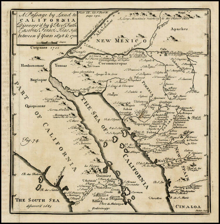
Courtesy of Barry Lawrence Ruderman Antique Maps – Rare Maps.com
The first half of the 18th century: Maps lagged behind reality however and it took until the middle of the 18th century for maps to reflect what Father Kino has rectified.
1747: King Ferdinand VI of Spain is finally convinced! He issues a royal decree proclaiming that indeed “California is not an island.”
Now back to the 21st century:
Now 80, Glen McLaughlin believes that other people than himself should enjoy those maps. At the end of 2011, Stanford University acquired his collection through a combination of donation and purchase. The collection can now be seen online (Glen McLaughlin Map Collection). You can also see a nice slideshow of 18 of these maps in this Wired article.
We’re curious to know if you know other stories of major mistakes on old maps.
If so, share your story with us in the comment area below!